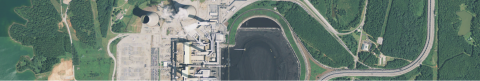
The team built a ground truth dataset comprising satellite images, building footprints, and building heights (LIDAR) of 40,000+ buildings, along with road annotations. This dataset can be used to train computer vision algorithms to determine a building’s volume from an image, and is significant contribution to the broader research community with applications in urban planning, civil emergency mitigation and human population estimation.
Project Results
Download the Executive Summary (PDF)
Faculty Sponsors
- Richard Newell, Director, the Energy Initiative at Duke
- Leslie Collins, Duke University Electrical and Computer Engineering
- Timothy Johnson, Energy and the Environment
- Kyle Bradbury, Managing Director, Energy Data Analytics Lab
Project Managers
- Sunith Suresh MS Candidate, Statistics
- Hoël Weisner Master of Environmental Management, Nicholas School
Participants
- Benjamin Brigman, Columbia University Electrical and Computer Engineering
- Sophia Park, Duke University Biomedical Engineering