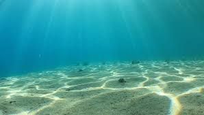
William Willis (Mechanical Engineering, Physics) and Qitong Gao (Masters Mechanical Engineering) spent ten weeks with the goal of mapping the ocean floor autonomously with high resolution and high efficiency. Their efforts were part of a team taking part in the Shell Ocean Discovery XPRIZE, and they made extensive use of simulation software built from Bellhop, an open-source program distributed by HLS Research.
Project Results: The team adapted Synthetic Aperture Sonar (SAS) methodology to produce high-resolution images. They also built a Convolutional Neural Network that classified, with high accuracy, different features on the ocean floor.
Partially funded by the Duke Marine Lab
Click here for the Executive Summary
Faculty Leads:
Project Manager: Vaishakhi Mayya

![]()
“We made a lot of progress that would not have happened otherwise.” — Martin Brooke, Associate Professor of Electrical and Computer Engineering, Pratt School of Engineering